

Houma
Attested 1492 CE – 1700 CE
Native American tribe located in Louisiana, United States
Wikipedia
The opening of the article, and a way into the rest of it without leaving the site.
Houma people on Wikipedia.
From Wikipedia, available under CC BY-SA 4.0.
How these dates were made
Why this bar's edges are floors, not a founding and a fall.
The atlas draws the world at 5 moments in time, not continuously. This bar runs from the first snapshot in which Houma appears to the last, so both edges are floors — the earliest and latest years it is attested, not a founding and a dissolution.
Elsewhere in Americas at the time
Records whose own span overlaps this one, found by the same test the canvas draws with. The bar under each card is where it sits inside this one.

Landmark · Americas
Pachacamac
200 CE – 1533 CE
Polity · Americas
Maya chiefdoms and states
2000 BCE – 1521 CETrade route · Americas
Mesoamerican Trade Network
1200 BCE – 1521 CEConflict · Americas
Tongan Maritime Power and Rivalries
1200 CE – 1600 CE
Landmark · Americas
Kuelap
500 CE – 1570 CE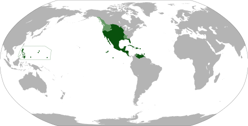
Polity · Americas
Vice-Royalty of New Spain
Attested 1530 CE – 1815 CETrade route · Americas
Qhapaq Ñan (Inca Royal Road)
1400 CE – 1572 CEConflict · Americas
Beaver Wars (Iroquois Wars)
1609 CE – 1701 CEDated moments inside this span
Events the timeline places between 1492 CE and 1700 CE.
And in the rest of the world
Records running through the same years, on the other side of the map.
Image credits5 pictures from Wikimedia Commons
- Houma peopleNikater · CC BY-SA 4.0
- PachacamacApollo⠀ · CC BY 2.0
- Maya civilizationKmusser · CC BY-SA 3.0
- KuélapMartin St-Amant ( S23678 ) · CC BY 3.0
- Map of the Viceroyalty of New SpainEddo · CC BY-SA 3.0


