
How these dates were made
Why this bar's edges are floors, not a founding and a fall.
The atlas draws the world at 3 moments in time, not continuously. This bar runs from the first snapshot in which Boihaenum appears to the last, so both edges are floors — the earliest and latest years it is attested, not a founding and a dissolution.
Elsewhere in Europe at the time
Records whose own span overlaps this one, found by the same test the canvas draws with. The bar under each card is where it sits inside this one.

Landmark · Europe
Colosseum
80 CE – still standing
Polity · Europe
Dacia
59 BCE – 106 CE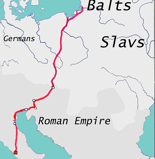
Trade route · Europe
Amber Road
1000 BCE – 400 CE
Conflict · Europe
Roman–Germanic Wars
12 BCE – 16 CE.jpg/500px-Timgad_(15685889550).jpg)
Landmark · Europe
Timgad
100 CE – 700 CE
Polity · Europe
Odrysian Kingdom
459 BCE – 46 CETrade route · Europe
Roman Mediterranean Trade
27 BCE – 476 CE
Conflict · Europe
Roman Conquest of Britain
43 CE – 84 CEDated moments inside this span
Events the timeline places between 1 BCE and 200 CE.
And in the rest of the world
Records running through the same years, on the other side of the map.
Image credits7 pictures from Wikimedia Commons
- ColosseumFeaturedPics · CC BY-SA 4.0
- DaciaPortasa Cristian · CC0
- Amber RoadBearas · CC BY-SA 3.0
- Chronology of warfare between the Romans and Germanic peoplesOtto Albert Koch · Public domain
- TimgadDan Sloan · CC BY-SA 2.0
- OdrysianAlexikoua · CC BY-SA 3.0
- Roman conquest of Britainmy work · CC BY-SA 3.0


.jpg)

