

Landmark Europe archaeological
Hadrian's Wall
122 CE – still standing
Roman frontier fortification stretching across northern England
Wikipedia
The opening of the article, and a way into the rest of it without leaving the site.
Hadrian's Wall on Wikipedia.
From Wikipedia, available under CC BY-SA 4.0.
Who held this ground
Borders from dated snapshots, up to a century apart; precision varies.
Reconstruction
- Before it was built (3000 BCE–100 CE)
- No border recorded here in this snapshot (200 CE–700 CE)
- Celtic kingdoms (800 CE–900 CE) Border precision: Approximate
- Scotland (1000 CE–1200 CE) Border precision: Approximate
- English territory (1279 CE–1400 CE) Border precision: Approximate
- England (1492 CE–1500 CE) Border precision: Approximate
- England and Ireland (1530 CE–1700 CE) Border precision: Approximate
- United Kingdom (1715 CE) Border precision: Defined
- Kingdom of Great Britain (1783 CE–1800 CE) Border precision: Defined
- United Kingdom of Great Britain and Ireland (1815 CE–1930 CE) Border precision: Defined
- United Kingdom (1938 CE–2026 CE) Border precision: Defined
Border precision
- Defined
- Approximate
Elsewhere in Europe at the time
Records whose own span overlaps this one, found by the same test the canvas draws with. The bar under each card is where it sits inside this one.

Landmark · Europe
Temple of Artemis at Ephesus
550 BCE – 262 CE
Polity · Europe
Ottoman Empire
1299 CE – 1922 CE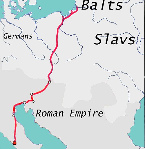
Trade route · Europe
Amber Road
1000 BCE – 400 CE
Conflict · Europe
World War I
1914 CE – 1918 CE
Landmark · Europe
Statue of Zeus at Olympia
435 BCE – 426 CE
Polity · Europe
Holy Roman Empire
962 CE – 1806 CETrade route · Europe
Roman Mediterranean Trade
27 BCE – 476 CE
Conflict · Europe
World War II
1939 CE – 1945 CEDated moments inside this span
Events the timeline places between 122 CE and 2026 CE.
And in the rest of the world
Records running through the same years, on the other side of the map.
Image credits 8 pictures from Wikimedia Commons
- Hadrians Wall map Hadrians_Wall_map.png : Created by NormanEinstein, September 20, 2005 derivative work: Ta… · CC BY-SA 3.0
- Temple of Artemis Philip Galle · Public domain
- Flag of the Ottoman Empire (1844–1922) User:Orwellianist · Public domain
- Amber Road Bearas · CC BY-SA 3.0
- World War I Collection DocAnciens/docpix.fr · Public domain
- Statue of Zeus at Olympia Quatremère de Quincy · Public domain
- Banner of the Holy Roman Emperor with haloes (1430-1806) David Liuzzo, eagle by N3MO · CC BY-SA 3.0
- World War II Richard Opitz · CC BY-SA 3.0 de


